
When the earthquake devastated Haiti, Laura McLay asked if OR is helping with the relief efforts. I’ve been wondering the same thing, and I went to a “Crisis Camp” this weekend to see if there is anywhere I could plug in.
This Crisis Camp business is hard to describe, and I didn’t really know what I was getting into when I showed up, and it seems like most of the other participants didn’t either. But we all woke up for a 9 AM meeting on Saturday, and we all wanted to do something good for the people of Haiti.
This isn’t exactly something you can make an impact on in a day, and the only tangible result of my work was fixing a typo on a wiki, but I did learn a little bit about what is going on. One group of geographers did a quick course on Open Street Maps and was able to start helping in an effort to update the maps of Port-au-Prince, tagging blocked roads, collapsed buildings, etc.
I joined group that connected with an ongoing project to find hospitals outside Port-au-Prince and help them share information about available capacity with people who need medical attention. Like I said, I didn’t manage to help with this in a day, but I did learn about this Sahana project and their success in finding the lat and long of 100 hospitals in Haiti.
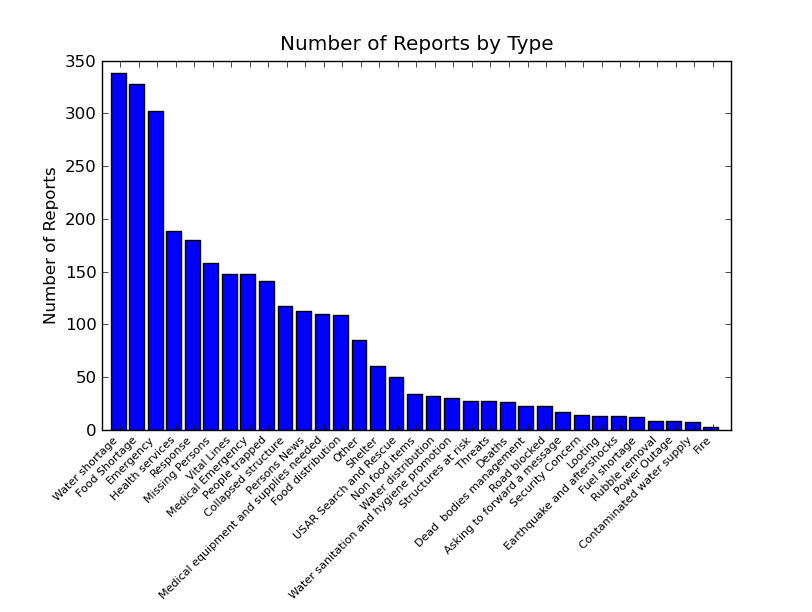
Another impressive data sharing tool that I a look at is Ushahidi, which I had heard about before, but never seen in action. This is a project that has a free SMS gateway for people in Haiti to use to report emergencies or share information. They translate messages into english and post them on the web with a CC-BY-SA license. I started looking at them yesterday, and they can be heartwrenching. Here is the breakdown by category, as of last night:
Does this inspire any operations research solutions? It makes me think of vehicle routing, if the earthquake damage tags in Open Street Maps show which roads are closed, that is:

I’m not sure if they do. (Red is map features with the tag earthquake:damage, but those are mostly IDP camps.)
